To northwest Montana, water is perhaps the most vital and valuable natural resource. An understanding…

NW MT report from DWSAC meeting
The Drought Water Supply Advisory Committee (DWSAC) serves as a clearinghouse for information on water supply conditions and drought mitigation actions. It is chaired by the Lieutenant Governor, and consists of representatives from the departments of Natural Resources and Conservation; Agriculture; Commerce; Fish, Wildlife, and Parks; Military Affairs; Environmental Quality; and Livestock.
The DWSAC met on June 19, 2018. I attended the meeting and prepared a summary of information relevant to northwest Montana. Scroll down for an overview, and click on the link below to read the full meeting summary for northwest Montana, including basin-specific reports from the Kootenai, Flathead, and Upper Clark Fork.
There has been above-normal precipitation in parts of western and central Montana (with the exception of Lincoln County which is way behind in precipitation so far this growing season). This is expected because May and June are generally the wettest months of the year. But, the effects of drought can be delayed depending on local conditions and ecological considerations (e.g., age of trees). Data for calendar year and water year 2018 suggest that most of the state is above normal for precipitation, but this isn’t the whole picture. Temperatures in western Montana stayed above normal during water year:
High elevations had record snow packs that lead to record-setting flows in some basins, but peak runoffs came weeks early this year. 1000-hr (large diameter) fuels did not “recover” over winter (i.e., did not get to sit in the moisture for very long due to quick runoff = extremely dry by fire season).
The combination of last year’s drought conditions plus the May/June conditions this year have lead to delay in green-up statewide.
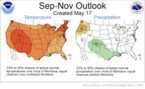
There is an El Nino watch in the forecast, which means hot and dry conditions for western Montana:
Current projections show NW Montana missing out on precipitation/moisture over the short- and long-term:
The outlook for the 2018 wildfire season is an above-average fire season for west-central MT to the Idaho panhandle. Current precipitation patterns are expected to change around mid-July to hot and dry conditions. NW Montana will be a wildfire hotspot if temperatures heat up and precip cuts off like last year.
Click the link below to read the full report on information from the DWSAC meeting relevant to northwest Montana:


